


New Model of Earth’s Interior Reveals Clues to Hotspot Volcanoes
October 29, 2013
By Linda Vu
Contact: cscomms@lbl.gov
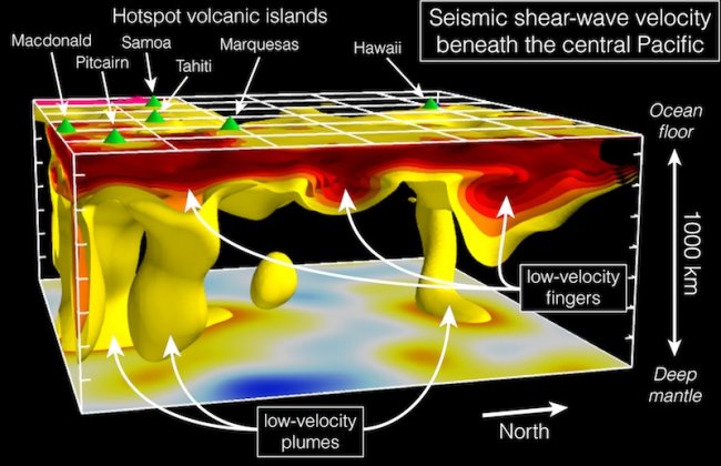
This 3D view of the top 1,000 kilometers of Earth’s mantle beneath the central Pacific shows the relationship between seismically-slow “plumes” and channels imaged in the UC Berkeley study. Green cones on the ocean floor mark islands associated with “hotspot” volcanoes, such as Hawaii and Tahiti. (Image courtesy of Berkeley Seismological Laboratory, UC Berkeley)
Using supercomputers at the Department of Energy’s National Energy Research Scientific Computing Center (NERSC), scientists have detected previously unknown channels of slow-moving seismic waves in Earth’s upper mantle. This discovery helps to explain how “hotspot volcanoes”—the kind that give birth to island chains like Hawaii and Tahiti—come to exist.
The researchers from UC Berkeley and University of Maryland found these channels by analyzing seismic wave data from about 200 earthquakes using highly accurate computer simulations of how these waves travel through the Earth’s mantle— the layer found between the planet’s crust and core. These analyses allowed them to make inferences about the structure of convection in the mantle, which is responsible for carrying heat from the planet’s interior to the surface to create hotspot volcanoes. Their paper was published in a recent issue of Science.
“We now have a clearer picture that can help us understand the ‘plumbing’ of Earth’s mantle responsible for hotspot Volcano Islands like Tahiti and Samoa,” says Scott French, a UC Berkeley Graduate Student and lead author on the paper.
What Causes Volcano Islands to Erupt?
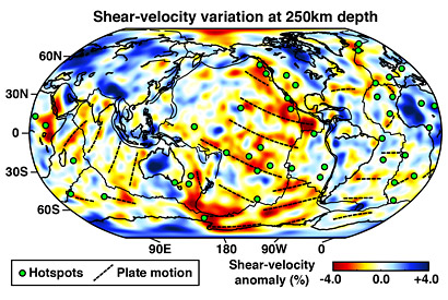
A map view of seismic shear-wave speed in Earth’s upper mantle. The warm colors highlight slow wave-speed channels. Where present, the channels align with the direction of tectonic-plate motion, shown as dashed lines. (Image courtesy of Berkeley Seismological Laboratory, UC Berkeley)
Unlike volcanoes that emerge from collision zones between tectonic plates, hotspot volcanoes form in the middle of plates. Geologists hypothesize that mantle plumes—hot jets of material that rise from deep inside the mantle, perhaps near the core-mantle boundary—supply the heat that feed these mid-plate volcanic eruptions.
But that model does not easily explain every hotspot volcano chain, or why large swaths of the seafloor are significantly hotter than expected. These observations suggest that the interaction between the plumes and the mantle’s large-scale convection cycle, which drives the conveyor belt that causes tectonic plates to creep over millions of years, is much more complex.
To learn more about the mantle’s structure and convection, French looked at seismic data from hundreds of earthquakes around the world. These energetic waves travel for long distances below Earth’s surface and are tracked by a global network of seismographs.
Because the waves change as they travel through different materials, scientists can gain insights about the structure and composition of the substances beneath the planet’s surface by analyzing the altered waves. This process—called seismic tomography—is very similar to the way CT (computed tomography) scans are used to reveal hidden structures inside the human body. But because researchers cannot directly observe the structures lurking below Earth’s surface, seismic tomography can be harder to interpret.
“To simulate seismic data for interpretation, people have traditionally used broad layers of approximation because it would have been too computationally heavy to run an exact model using numerical simulations,” says French.
He notes that it is only within the last five years researchers have had access to the computing technology to simulate the entire planet’s response to one earthquake using numerical simulations. “One simulation of one earthquake takes about 144 computer processor hours on NERSC’s Hopper system,” says French. “But we needed to run this simulation for 200 individual earthquakes to get an accurate seismic model. Our model improves with each run.”
As a graduate student in Barbara Romanowicz’s research group at UC Berkeley back in 2010, Vedran Lekic used supercomputers at NERSC to develop a method to accurately model seismic wave data while keeping computing time manageable. French recently refined this approach, further improving the accuracy of the tomography, while also scaling the technique to solve larger problems. Together, these efforts resulted in higher-resolution images of patterns of convection in the Earth’s mantle. Without these new techniques, Lekic notes that the study’s analysis would have taken about 19 years to compute.
This tomographic model eventually allowed the team to find finger-like channels of low-speed seismic waves traveling in the mantle about 120 to 220 miles beneath the sea floor. These channels stretch about 700 miles wide and 1,400 miles apart. Seismic waves typically travel about 2.5 to 3 miles per second at this depth, but waves in the channels traveled significantly slower – about 4 percent. Because higher temperatures slow down seismic waves, scientists inferred that material in the channels must be hotter than surrounding material.
“We estimate that the slowdown we’re seeing could represent a temperature increase of up to 200 degrees Celsius (about 390 degrees Fahrenheit),” says French, who notes that absolute temperatures in the mantle are typically about 1,300 degrees Celsius, or 2,400 degrees Fahrenheit at this depth.
“We believe that plumes, accompanied by complex interactions with the upper mantle, contribute to hotspots and observations of high heat flow. The exact nature of these interactions will need further study, but the low-velocity channels represent an important piece of the puzzle,” says French. “To solve these large problems we need supercomputers, like NERSC’s Hopper, with sufficient processing power to support the thousands of earthquake simulations necessary for global-scale geophysical imaging.”
In addition to French, Lekic and Romanowicz were also co-authors on the paper. Lekic is currently an assistant professor of geology at the University of Maryland’s College Park Campus.
See the original UC Berkeley Press Release.
About NERSC and Berkeley Lab
The National Energy Research Scientific Computing Center (NERSC) is a U.S. Department of Energy Office of Science User Facility that serves as the primary high performance computing center for scientific research sponsored by the Office of Science. Located at Lawrence Berkeley National Laboratory, NERSC serves almost 10,000 scientists at national laboratories and universities researching a wide range of problems in climate, fusion energy, materials science, physics, chemistry, computational biology, and other disciplines. Berkeley Lab is a DOE national laboratory located in Berkeley, California. It conducts unclassified scientific research and is managed by the University of California for the U.S. Department of Energy. »Learn more about computing sciences at Berkeley Lab.